


Rando Apiculture Villefermoy

jeanmarcMasson
User GUIDE
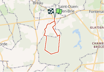

Length
8.9 km

Max alt
132 m

Uphill gradient
72 m
Km-Effort
9.9 km

Min alt
94 m

Downhill gradient
72 m
Boucle
Yes
Creation date :
2025-04-30 08:08:08.714
Updated on :
2025-04-30 10:13:12.035
1h55
Difficulty : Medium

FREE GPS app for hiking
 SityTrail
IGN / Geographical institutes
SityTrail Plus
The world is yours!
About
Trail Walking of 8.9 km to be discovered at Ile-de-France, Seine-et-Marne, La Chapelle-Gauthier. This trail is proposed by jeanmarcMasson.
Positioning
Country:
France
Region :
Ile-de-France
Department/Province :
Seine-et-Marne
Municipality :
La Chapelle-Gauthier
Location:
Unknown
Start:(Dec)
Start:(UTM)
492701 ; 5377458 (31U) N.
Comments